
A Technical Foundation for Unmanned Excellence
Welcome to the Statenville command center for Fair Lifts Unmanned. Securing an estimate for industrial-scale drone integration is more than a simple pricing inquiry; it is the start of a high-level partnership designed to optimize your harvest returns, protect your infrastructure, and streamline your regulatory reporting. Our project leads are more than just account managers; they are technical specialists rooted in the South Georgia landscape, dedicated to transforming your specific operational requirements into a sophisticated, data-backed strategy.
In the heart of the Coastal Plain, the business and agricultural sectors move at a pace dictated by the seasons and the demands of regional industry. From timber managers monitoring vast pine stands near the Florida line to vegetable growers managing critical windows in the sandy loam of Statenville, we recognize that your mission is time-sensitive. Our "Strategize. Deploy. Validate." methodology guarantees that every engagement is handled with urgency, total transparency, and uncompromising accuracy.
The Statenville Precision Methodology
Phase 01: The Echols County Assessment
Every high-performance mission begins with a deep dive into local variables. For our agricultural clients, this involves a thorough review of field topographies, specific crop varieties—including peanuts, carrots, and pecans—and current pest or disease pressures. For our industrial and engineering partners, we analyze site constraints, required data resolution, and specific software compatibility. We reject "one-size-fits-all" approaches. In the South Georgia Coastal Plain, we specifically account for variables like sandy soil drainage, high humidity levels, and regional airspace nuances during the planning phase.
Phase 02: High-Performance Implementation
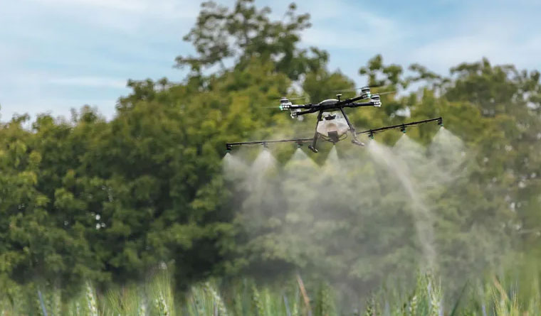
Once the strategy is finalized, our expert flight crews mobilize. Stationed locally in Statenville, we offer a rapid-response capability that out-of-town contractors cannot match. We utilize the industry’s most advanced hardware, ranging from our heavy-duty XAG P150 application drones to our WingtraOne mapping platforms. Operating under strict aviation-grade safety protocols, we deliver centimeter-accurate results while maintaining the highest regard for regional safety standards and environmental stewardship.
Phase 03: Actionable Data Distribution
The mission isn't considered complete until you possess the insights required to make critical decisions. For agricultural spray applications, you receive a comprehensive "As-Applied" report providing total transparency on coverage and volume. For surveying and mapping, we provide professional-grade 3D models, LiDAR point clouds, or orthomosaics in the CAD and GIS formats your team already utilizes. We close the loop by verifying that every deliverable aligns with your projected ROI.
Regional Resilience and Commitment
Our investment in Statenville extends far beyond the flight path. We are dedicated to the long-term economic vitality of the Echols County region. To support our local partners, we provide preferred rates for multi-season and multi-year service agreements. By establishing a partnership early, you secure priority scheduling during those high-demand summer months when equipment access across the Coastal Plain is at a premium. We serve as your year-round technology department, managing the fleet and the data so you can focus on managing your business.
Frequently Asked Questions
Project Intake Form
Statenville Regional Office
Ready to Start Your Project?
Discuss your specific goals in Statenville with a regional expert. We provide rapid mobilization and precision scoping for every regional client.